


Latest Update:
The catastrophic collapse of Anak Krakatau in 2018, which triggered a deadly tsunami, was preceded by years of subtle ground deformation. This previously undetected movement was recently revealed through advanced satellite radar imaging.
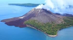
Overview of Anak Krakatau
- Anak Krakatau, meaning “Child of Krakatau”, is a stratovolcano located in Indonesia’s Sunda Strait, nestled between the islands of Java and Sumatra.
- It lies along the Pacific Ring of Fire, a major zone known for intense seismic and volcanic activity.
- This volcano began forming in 1927, emerging from the sea as a direct consequence of the legendary 1883 Krakatoa eruption, one of the most powerful eruptions in recorded history.
- Over the decades, frequent strombolian-type eruptions have contributed to the volcano’s steady growth.
- The volcano is positioned above multiple interconnected magma chambers, fueling its activity.
Eruption History and 2018 Disaster
- Anak Krakatau has experienced at least nine eruptive episodes since 1963, most of which have been brief, typically lasting less than a year.
- On December 22, 2018, the volcano underwent a significant eruption that caused the southwestern flank to collapse into the sea.
- This collapse resulted in a massive underwater landslide, which in turn generated a tsunami that severely affected the coastal regions of southern Sumatra and western Java, leading to widespread destruction and loss of life.