


Context
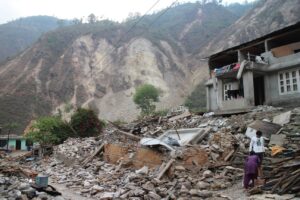
- Monsoon 2025 triggered severe floods and landslides in J&K, Himachal, Punjab, and Uttarakhand.
- Massive damage: over 140 lives lost, pilgrimages disrupted, homes swept away.
- Emergency responses involved:
- Army aviation, Air Force helicopters, NDRF, SDRF, SASE, and SDRF teams.
- Drone usage, satellite communication, Doppler radars, OneWeb links, and mobile ATC units.
- GSI and NRSC tasked with landslide mapping and real-time lake/river monitoring.
- Importance of GIS mapping, multi-layered response systems, and community preparedness highlighted.
Challenges in Himalayan Disaster Management:
- Fragile and unstable topography.
- Intensifying climate change effects: cloudbursts, flash floods, landslides.
- Increasing human encroachment, construction in eco-sensitive zones.
- Communication breakdowns in remote mountainous areas.
Systemic Gaps Identified:
- Mock drills and training still seen as tokenism.
- Lack of penetration of disaster education in schools and communities.
- Absence of dedicated no-build zones in ecologically fragile areas.
- Need for scientific and localised early warning systems.
Recommendations from the Article:
Technology Integration:
- Massive scale-up of:
- Drones, GIS, satellite imagery, Doppler radars.
- Use of OneWeb, IMD forecasts, satellite-based slope stability maps.
- GSI must expand landslide mapping using slope, soil data.
- NRSC must monitor glacial lake outbursts (GLOFs) and river flows 24×7.
Community and Institutional Readiness:
- Awareness messages via SMS (e.g., SACHET system in J&K).
- Mock drills should become regular training events.
- NDMA’s ‘Aapda Mitra’ program must be expanded and made more actionable.
- Civil society and disaster professionals must collaborate.
Build Back Better Approach:
- Roads, bridges, and public infrastructure must be resilient to future disasters.
- Network of community shelters, emergency communication nodes, and pilgrimage management plans essential.