


GS1 – Art & Culture
Context:
The Geological Survey of India (GSI) has granted Geo-Heritage Site status to the Belum Caves located in Andhra Pradesh’s Nandyal district.
Key Details about Belum Caves
- Initially identified in 1884 by Robert Bruce Foote, the caves were later extensively surveyed between 1982 and 1984 by H.D. Gebauer.
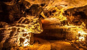
- These caves were naturally carved from black limestone due to prolonged action of subterranean water flow.
- Inside, one can find spectacular stalactites (hanging from the ceiling) and stalagmites (rising from the ground), which over time merge into natural columns.
- Foote is notably remembered as the Father of Indian Prehistory for discovering the first Paleolithic tool in India at Pallavaram.
Cultural and Geological Significance
- Belum Caves were once occupied by Buddhist and Jain monks; evidence includes a Shiva Lingam and the presence of a natural spring called Patalaganga.
- The internal climate remains stable at around 33°C year-round.
- It is believed that the underground water here connects to nearby village wells and is influenced by the Penna River.
- Archaeological digs have uncovered artifacts over 4,500 years old, pointing to habitation before the Buddhist era.
- Some of the cave’s distinctive chambers include Meditation Hall, Thousand Hoods, Airavatham, and Mayamandiram.
- Belum stands as the second-longest natural cave system in India. The longest globally is the Mammoth Cave in the USA, while Krem Liat Prah in Meghalaya holds the title within India.
Geological Features
- Stalactites are mineral formations suspended from the ceiling, created by the continuous dripping of mineral-rich water—shaped like tapering icicles.
- Stalagmites, formed on the cave floor below stalactites, arise from the same dripping process and may fuse with stalactites to form pillar-like formations, changing the cave’s interior structure.
Geo-Heritage Sites – Overview
- These are areas with exceptional geological or paleontological value, such as caves, rock forms, fossils, meteorites, or stratified rock layers.
- Managed by the Geological Survey of India, such sites are protected for purposes including research, conservation, public education, and tourism.
- Other prominent geo-heritage sites in India include Lonar Crater (Maharashtra), St. Mary’s Island (Karnataka), and Erra Matti Dibbalu (Andhra Pradesh).
About the Geological Survey of India (GSI)
- Established in 1851, following earlier groundwork by John McClelland in 1846 under the East India Company, and formalized under Thomas Oldham.
- One of India’s earliest scientific organizations, second only to the Survey of India (1767).
- Operates under the Ministry of Mines as an attached office.
- Headquartered in Kolkata, with regional and state offices across the country.
- Its mandate includes conducting geoscientific research, mineral resource surveys, natural hazard assessments, and overseeing geo-heritage conservation.