


GS1 – Geography
Context :
A rare crescent-shaped weather formation observed over Delhi was identified by IMD radar as a “bow echo”.
Understanding Bow Echo:
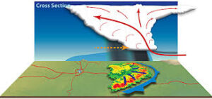
Definition: A bow echo is a curved band of thunderstorms, also known as a squall line, which appears on radar in the form of an archer’s bow. It can also form as part of a larger squall system.
These are not new to India and have been witnessed during strong thunderstorm events.
Origin: The term “bow echo” was first used in the 1970s by Ted Fujita, a renowned Japanese-American meteorologist who also created the Fujita Scale for tornado classification.
Weather Impact: These systems are linked with severe weather such as strong winds, heavy rainfall, and significant damage over wide areas.
Size and Duration: They generally span between 20–100 km and persist for about 3 to 6 hours.
Formation Process:
- Gust Front Formation: The process begins when rain-cooled air sinks and spreads outward at the surface, creating a boundary called a gust front, separating cool outflow from warm surface air.
- New Storm Generation: The gust front forces warm moist air to rise, forming new thunderstorms. These, in turn, produce additional rainfall and reinforce the gust front.
- Bow Shape Creation: As the system strengthens, rear inflow winds push the storm line forward, forming a bow-shaped radar signature.
The bow echo continues to move forward as long as new storms emerge along its leading edge, often causing strong straight-line winds.
Derecho Classification:
If such a system travels more than 400 km (250 miles) with wind speeds over 93 km/h (58 mph) across a broad area, it is termed a “derecho”.