


GS3 – Science & Technology
Context:
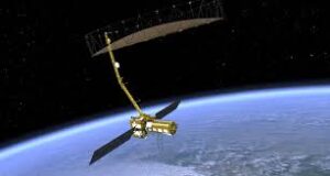
NISAR, a joint Earth-observation satellite developed by NASA and ISRO, is scheduled for launch on July 30 via GSLV F16 from the Satish Dhawan Space Centre.
Mission Highlights:
- Duration: Designed for a three-year operational life.
- Orbit: Will operate in a Sun-synchronous low Earth orbit at 747 km, revisiting the same location every 12 days.
- Innovation: The first radar-imaging satellite to utilise dual-frequency radar—S-band and L-band.
- Cost & Mass: One of the costliest missions at $1.5 billion, with a total launch mass of 2,800 kg.
Radar Capabilities:
- Equipped with a 12-meter-wide Synthetic Aperture Radar (SAR) antenna.
- Uses Sweep SAR technology to provide high-resolution 3D imagery over a swath of 242 km.
- Operates effectively under all weather conditions, including cloud cover and darkness, by emitting microwave pulses instead of relying on visible light.
Radar Specifications:
- L-band SAR (NASA – JPL): ~24 cm wavelength; penetrates vegetation and surface layers. Used for monitoring biomass, tectonic movements, and ice dynamics.
- S-band SAR (ISRO): ~10 cm wavelength; detects surface changes. Useful in studying natural disasters such as earthquakes, volcanoes, and landslides.
Key Applications:
- Monitor land surface deformation and tectonic activity.
- Enable disaster management with timely data on floods, landslides, and seismic events.
- Track changes in glaciers and polar ice sheets for climate studies.
- Assess agricultural biomass, forest degradation, crop conditions, and soil moisture.