


Prelims Bits
Context
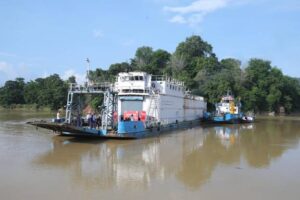
National Waterway-57 (NW-57), located on the Kopili River in Assam, has been operationalised with a successful trial cargo movement between Chandrapur (Kamrup) and Hatsingimari (South Salmara).
About National Waterway 57
- Geographical Span:
NW-57 stretches over 46 km entirely along the Kopili River in Assam. - Managing Body:
The waterway is administered by the Inland Waterways Authority of India (IWAI) under the Ministry of Ports, Shipping & Waterways. - Purpose:
Designed to facilitate intra-state cargo transport, it aligns with the objectives of the Maritime India Vision 2030.
Importance of NW-57
- Revitalising Inland Transport:
Enhances Assam’s inland water transport network, thereby invigorating regional commerce and connectivity. - Sustainable Modal Shift:
Encourages a shift from road to water-based freight, aiding in reduced emissions and easing road congestion. - Expansion of Assam’s Water Cargo Network:
The operationalisation of NW-57 adds to 1,168 km of navigable water routes in the state, spanning:- NW-2 (Brahmaputra)
- NW-16 (Barak)
- NW-31 (Dhansiri)
- NW-57 (Kopili)
About the Kopili River
- Interstate River:
Flows through Meghalaya and Assam. - Origin:
Rises in the Saipung Reserve Forest located within the Borail Range of Meghalaya at an elevation of approximately 1,525 metres. - Confluence:
Acts as a south-bank tributary to the Brahmaputra River. - Drainage Coverage:
Encompasses areas such as North Cachar Hills, Karbi Anglong, Nagaon, and Morigaon districts. - Biodiversity Note:
The Kopili Valley is home to Carissa kopilii, a rare and endemic plant species.