


GS 3
NASA researchers have introduced a groundbreaking concept involving quantum gravity gradiometers (QGGs), aiming to track how Earth’s mass distribution evolves over time—particularly in response to climate change. Their proposal involves deploying these advanced instruments aboard satellites to enhance our understanding of global mass shifts.
What Is a Quantum Gravity Gradiometer (QGG)?
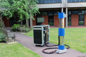
Quantum Gravity Gradiometers are ultra-sensitive devices designed to detect subtle changes in gravitational forces. NASA envisions using these tools in space to monitor Earth’s shifting mass with exceptional precision.
At the heart of a QGG is a cloud of atoms—typically of a specific element—cooled to temperatures close to absolute zero in a vacuum. In this ultra-cold state, the atoms behave like waves. Using laser beams, scientists manipulate these wave-like atoms, causing them to experience a phase shift that correlates directly with the gravitational forces acting upon them.
This technology allows for the detection of incredibly minute variations in acceleration—down to 10⁻¹⁵ meters per second squared—over distances as short as one meter. From low Earth orbit, QGGs can be used to:
- Assess the mass of massive geological structures, such as the Himalayas.
- Track the distribution and movement of water, ice sheets, and underground materials with remarkable accuracy.
How Gravitational Force Relates to Mass Distribution
Gravitational strength at any given location on Earth is influenced by the nearby mass. Areas with greater mass—like mountain ranges—exert stronger gravitational forces compared to less dense regions, such as flatlands or urban areas.
What Is a Gravity Gradiometer?
A gravity gradiometer is a precision instrument that measures how gravitational acceleration changes from one location to another. Even when an object, like a ball, is dropped, the gravitational pull it experiences can vary slightly due to underlying mass differences.
These instruments are already in use for applications such as geological exploration. For example, they help identify oil and gas reserves, which have lower densities compared to surrounding rock formations.