


GS1/GS3 – Geography & Disaster Management
Context
- IMD Director-General Mrutyunjay Mohapatra clarified:
- No “increasing trend” in cloudbursts in India.
- Cloudbursts remain “impossible” to forecast.
- However, “mini-cloudbursts” (localised but intense rainfall events) are increasing in frequency.
Key Highlights from IMD Update
- Monsoon 2025 performance (till Aug 31):
- 6% above normal rainfall (70 cm usual for June–Aug).
- September forecast: 9% above normal (avg. 16.7 cm).
- Regional trends:
- Northwest India (Uttarakhand, UP, Punjab, Haryana, Delhi, Rajasthan, J&K): 26% above normal.
- Central India: +8.6%.
- Southern Peninsula: +9.3% (3rd highest since 2001).
- Eastern & Northeastern India: -17% deficit (despite being the wettest monsoon bloc).
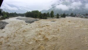
- Extremes in 2025:
- 700+ heavy rainfall events (>20 cm/day) in August 2025 (2nd highest since 2021).
- August rainfall in North India (26.5 cm) – highest since 2001.
- Reason for extremes:
- Confluence of Western Disturbances (from the Mediterranean) + Bay of Bengal monsoon systems → triggered episodes of intense rains in Himachal, J&K, Uttarakhand.
- Long-term trend:
- Since 1980, an increasing rainfall trend in September has been observed.
What is a Cloudburst?
- A sudden, intense rainfall event (≥100 mm/hour over a localized area, usually <20–30 sq. km).
- Often occurs in hilly terrains due to orographic lift (warm moist air forced upwards by mountains → rapid condensation → heavy downpour).
What is a Mini-cloudburst?
- No standard IMD definition, but refers to smaller-scale extreme rainfall events (typically <100 mm/hour but still destructive).
- Increasingly reported in urban and peri-urban areas due to local convective activity and urban heat island effect.
Why are Cloudbursts Difficult to Predict?
- Scale issue: They occur in micro-geographic areas.
- Require real-time, high-resolution radar and satellite data, which current IMD forecasting models cannot fully capture.
Vulnerable Regions in India
- Himalayan States: Uttarakhand, Himachal Pradesh, J&K, Northeast.
- Urban areas: Mumbai, Bengaluru, Chennai (due to drainage congestion).
Role of Western Disturbances
- Extra-tropical storms originating in the Mediterranean Sea.
- Travel eastwards, bringing sudden rainfall/snowfall in Northwest India.
- Intensify when interacting with monsoon systems from Bay of Bengal → trigger extreme rain events.